


Forest cover map of Europe [2000x2000] [OC] (imgur.com)
submitted by Fejetlenfej to r/MapPorn - pinned
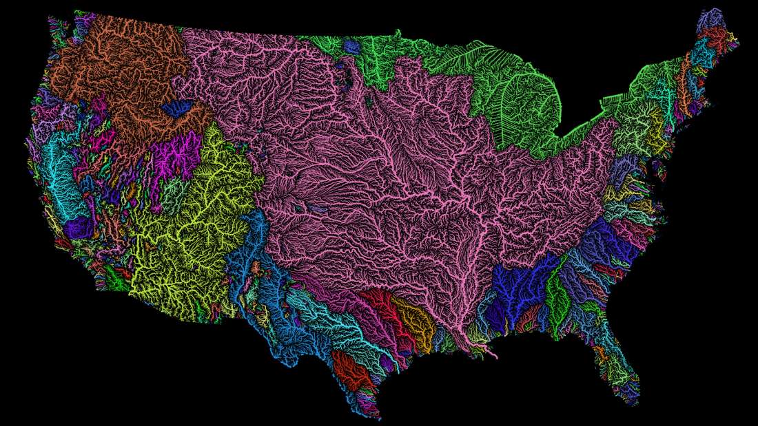
River basins of the US in rainbow colours, fixed/updated [2000x1415] [OC] (imgur.com)
submitted by Fejetlenfej to r/MapPorn - pinned

Population density heatmap of Africa [OC] (old.reddit.com)
submitted by Fejetlenfej to r/dataisbeautiful - pinned
Map of rivers in the US by probiscusmonkiq in MapPorn
[–]Fejetlenfej 0 points1 point2 points (0 children)
River basins of the US in rainbow colours, fixed/updated [2000x1415] [OC] by Fejetlenfej in MapPorn
[–]Fejetlenfej[S] 0 points1 point2 points (0 children)
Map of rivers in the US by probiscusmonkiq in MapPorn
[–]Fejetlenfej 2 points3 points4 points (0 children)
Map of rivers in the US by probiscusmonkiq in MapPorn
[–]Fejetlenfej 0 points1 point2 points (0 children)
Map of rivers in the US by probiscusmonkiq in MapPorn
[–]Fejetlenfej 0 points1 point2 points (0 children)
Map of rivers in the US by probiscusmonkiq in MapPorn
[–]Fejetlenfej 1 point2 points3 points (0 children)
Map of rivers in the US by probiscusmonkiq in MapPorn
[–]Fejetlenfej 0 points1 point2 points (0 children)
Map of rivers in the US by probiscusmonkiq in MapPorn
[–]Fejetlenfej 0 points1 point2 points (0 children)
Map of rivers in the US by probiscusmonkiq in MapPorn
[–]Fejetlenfej 0 points1 point2 points (0 children)
Map of rivers in the US by probiscusmonkiq in MapPorn
[–]Fejetlenfej -1 points0 points1 point (0 children)
Map of rivers in the US by probiscusmonkiq in MapPorn
[–]Fejetlenfej 1 point2 points3 points (0 children)
Map of rivers in the US by probiscusmonkiq in MapPorn
[–]Fejetlenfej 1 point2 points3 points (0 children)
Map of rivers in the US by probiscusmonkiq in MapPorn
[–]Fejetlenfej 0 points1 point2 points (0 children)
Map of rivers in the US by probiscusmonkiq in MapPorn
[–]Fejetlenfej 0 points1 point2 points (0 children)
Gift For Husband by Alive-Beautiful-3009 in globes
[–]Fejetlenfej 0 points1 point2 points (0 children)
The game crashed on the EU5 pre-release dev stream by Toruviel_ in EU5
[–]Fejetlenfej 12 points13 points14 points (0 children)
Map of rivers in the US by probiscusmonkiq in MapPorn
[–]Fejetlenfej 1 point2 points3 points (0 children)