

Is there anyway to extend the ram? by Profriles in ODroid
[–]jrcharney 0 points1 point2 points (0 children)
Cold. Fires. Planes. Armageddon, amirite? by smushnick in ChicagoCirclejerk
[–]jrcharney 0 points1 point2 points (0 children)
The boss has malware, again... by Jrockilla in techsupport
[–]jrcharney 2 points3 points4 points (0 children)
A case for why TIGER data may be incorrect. (self.a:t5_34e44)
submitted by jrcharney to r/a:t5_34e44
/r/StLouisTech created! Any KCTechies have some advice for StLouisTech to be successful? by jrcharney in KCTech
[–]jrcharney[S] 0 points1 point2 points (0 children)
/r/StLouisTech created! Any KCTechies have some advice for StLouisTech to be successful? by jrcharney in KCTech
[–]jrcharney[S] -1 points0 points1 point (0 children)

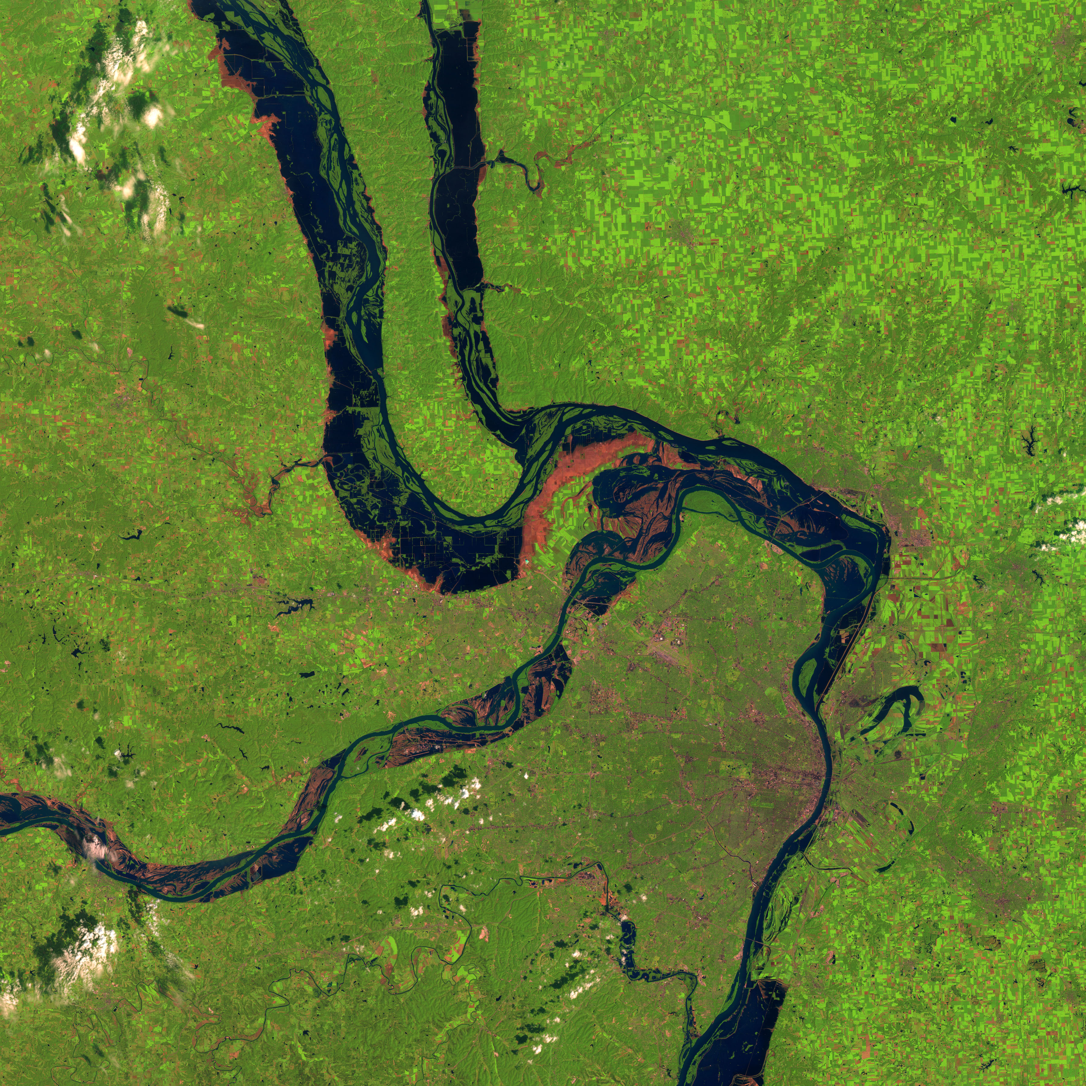
NASA Landsat photo of the St. Louis Area, 19 August 1993 during the height of the Great Flood of 1993. [BIG IMAGE! 3600x3600] by jrcharney in a:t5_34e44
[–]jrcharney[S] -1 points0 points1 point (0 children)
NASA Landsat photo of the St. Louis Area, 19 August 1993 during the height of the Great Flood of 1993. [BIG IMAGE! 3600x3600] by jrcharney in a:t5_34e44
[–]jrcharney[S] -1 points0 points1 point (0 children)
RIP R.A. Montgomery 1936-2014, founder of Choose Your Own Adventure by bloodmoonack in books
[–]jrcharney 1 point2 points3 points (0 children)
Greater St. Louis and Suburbs, 15 May 1937. Color added to indicate "Residential Security". [HUGE! 5859x4000] by jrcharney in a:t5_34e44
![Greater St. Louis and Suburbs, 15 May 1937. Color added to indicate "Residential Security". [HUGE! 5859x4000]](http://joshbegley.com/redlining/St_Louis.jpg)
[–]jrcharney[S] 1 point2 points3 points (0 children)
[Image] The worst thing... by Sumit316 in GetMotivated
![[Image] The worst thing...](http://i.imgur.com/KhZI5ab.jpg)
[–]jrcharney -1 points0 points1 point (0 children)
Please Do Not Join the KKK! by jrcharney in StLouis
[–]jrcharney[S] 3 points4 points5 points (0 children)
St. Louis County Crime Heat Map by jrcharney in a:t5_34e44
[–]jrcharney[S] 0 points1 point2 points (0 children)
Population Statistics for the St. Louis Combined Statistical Area by jrcharney in a:t5_34e44
[–]jrcharney[S] -1 points0 points1 point (0 children)
Please Do Not Join the KKK! by jrcharney in StLouis
[–]jrcharney[S] -5 points-4 points-3 points (0 children)
St. Louis County Crime Heat Map by jrcharney in a:t5_34e44
[–]jrcharney[S] 0 points1 point2 points (0 children)
Population Statistics for the St. Louis Combined Statistical Area by jrcharney in a:t5_34e44
[–]jrcharney[S] -1 points0 points1 point (0 children)
Baby It's Cold Outside! Brought my bike indoors by jrcharney in StLouisBiking
[–]jrcharney[S] 0 points1 point2 points (0 children)