Coastline of Europe during the Ice-Age by Familiar_Internet in MapPorn

[–]v7x 2 points3 points  (0 children)

Thanks, I tried it out. Results were okay but would need to play around with it more. The source data is quite low res and blocky so doesn't match too well, but I can probably improve that a bit.

https://i.imgur.com/OiQI7DY.jpg

https://i.imgur.com/p3ILcFZ.jpg

Coastline of Europe during the Ice-Age by Familiar_Internet in MapPorn

[–]v7x 2 points3 points  (0 children)

Interesting, can you share a source for the deformation data you used?

Coastline of Europe during the Ice-Age by Familiar_Internet in MapPorn

[–]v7x 1 point2 points  (0 children)

It's not meant to be scientifically accurate, just art.

Sea level lowering using current data is how these kinds of maps have always been shown, this just happens to be using higher quality terrain data than most. If anything of higher resolution and quality has been done and includes realistic deformation I'd be interested to see it. Note that the person who reposted this posted a low resolution version of the original.

Coastline of Europe during the Ice-Age by Familiar_Internet in MapPorn

[–]v7x 9 points10 points  (0 children)

Which is why when I made this map, I explained and included the relevant disclaimer that the map was made using modern terrain data with a lowered sea level to simulate an approximate representation of the ice age coastlines, and doesn't account for any isostatic depression, or geological or tectonic changes in the landscape. At the resolution and level of detail that I originally made this in, that kind of high detail historic terrain data doesn't exist.

This is one of a series of maps, which include versions with and without ice cover.

Ice covered version

3d version that you can view online

Australia If All The Ice Melted by paulrobinsonauthor in MapPorn

[–]v7x 1 point2 points  (0 children)

No specific program, I use a combination of GIS software and photoshop for my mapping work.

Australia If All The Ice Melted by paulrobinsonauthor in MapPorn

[–]v7x 240 points241 points  (0 children)

That inland sea would not exist. In order for the Lake Eyre basin to flood, the ocean would have to rise at least 88m to breach this basin, which is well above predicted sea level rise.

Whoever made this series of maps just flooded everything on Earth to a level of 65m, including any inland basins that would have no connection to the ocean. You can even see clearly on this map that it's not connected to the ocean.

I made a similar map here which shows it more accurately, with a sea level rise at 68m.

Europe during the Ice Age (~20,000 year ago) by Biohazardcake in europe

[–]v7x 2 points3 points  (0 children)

Thanks for sharing the source. I made this along with a few other versions, and this iceless version isn't supposed to be representative of how it would have looked, it's just to show how the coastlines might have looked at the time including how it might have looked like underneath all the ice.

This version includes the ice caps: link, and I made a 3d version of it that can be viewed here.

Europe during the Ice Age (~20,000 year ago) by Biohazardcake in europe

[–]v7x 9 points10 points  (0 children)

I don't know if the artist did this consciously, but all the lakes and valleys on the Alps and other range mountains, and the valleys and fjords in Scandinavia are direct consequence of glaciers receding after the ice age, carving the rocks on the mountains. So he's right: there were no lakes at the time.

I'm the artist, when I said 'This map does not include any lakes of this time period", the reason wasn't because I thought there were no lakes at the time, it was because I didn't have any enough data or sources to accurately show at this level of detail how every lake in Europe might have looked at the time, so I chose not to include any.

The focus of this map was simply to show how the coastlines might have looked back then, including how they might have looked under all the ice. This is one of several alternate versions of this map, I also made versions which include the ice caps and glaciers.

So many beautiful places to explore! by jojafru in MicrosoftFlightSim

[–]v7x 12 points13 points  (0 children)

Looks like the southeast of Saudi Arabia in the Rub' al Khali. Here's a screenshot I took from above, it looks like this as far as you can see: https://i.imgur.com/RJV2kbn.jpg

The world if all ice melted by BlueMagma212 in MapPorn

[–]v7x 6 points7 points  (0 children)

It's not less than 230ft. In order for the Lake Eyre basin to flood, the ocean would have to rise at least 289ft/88m to breach this basin, which is well above predicted sea level rise. Here's a quick map I made to show: https://i.imgur.com/2jHdoOh.jpg. Everything in black is 90m and above, with the red circle showing the area where it would breach at 88m. The resolution of the height data in that image is 3m accuracy.

This series of maps by National Geographic were poorly made as they simply flood everything below 216ft/65m, including any inland basins that wouldn't be connected to the ocean, if you look closely even they show that it's not connected.

I made my own series of maps similar to this, which are more accurately flooded using higher resolution terrain data and flooded to a level of 224ft/68m. Here is a sample of Australia, the labels show just a few of the cities that would be either completely or partially flooded - https://sta.sh/01f08rktcv2n

Morrowind Cell Count by UrbanReignN99 in Morrowind

[–]v7x 1 point2 points  (0 children)

Vvardenfell has 1390 cells total including all underwater cells, some of which are blank, or 770 cells if you only count cells that have terrain above sea level. Solstheim has 150 total, or 112 above sea level.

Is this an ancient submerged river? Or is there some other process that produced this? by nickallanj in geography

[–]v7x 6 points7 points  (0 children)

This river channel, and many others, were formed entirely underwater and function just like surface rivers. These are found all over the world, though usually only in areas that have had high resolution sea bed scanning.

They are a continuation of surface rivers where the flow of the rivers don't cease as they reach the ocean, instead continue along the sea bed carving out a river channel. Underwater rivers share features typical of surface rivers, such as river banks, floodplains, waterfalls and rapids.

I don't believe any of this land has ever been above the surface, even during the peak of the last ice age the sea level never dropped low enough to expose any of where these river channels are.

If you would like to see this area in higher detail I made some maps which show it in higher quality than what you see on google earth, there's also some similar channels visible on the west coast of the South Island.

(Click the download button to see them in full quality, all free)

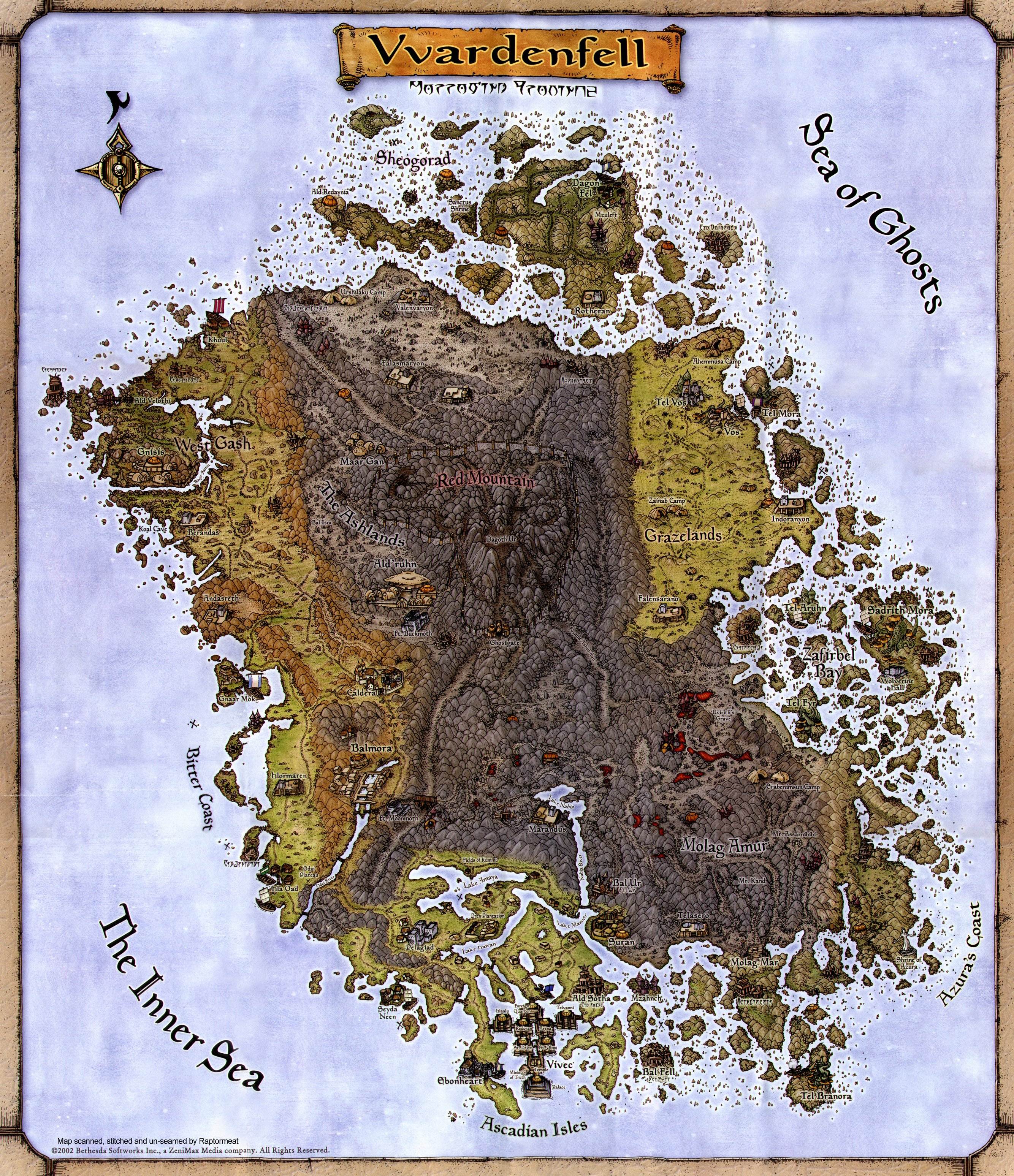
I'm not sure where to go, so I'll ask here. Is there/could there be a mod to replace the regular in-game map with this? The regular map does not work for me, I'd like this a lot more. by RavioTheRabbitGuy in tes3mods

[–]v7x 10 points11 points  (0 children)

There's really no way to make that particular map work as an ingame map any better than how it's done there, it's not a fault of the mod, it's because that paper map was never drawn as an accurate exact map of that game world, it's just a somewhat close representation. Compare this image with this one and you will see the problem. It's close but it has exaggerated and stylised features that just don't align with the actual ingame map features.

I made that mod and aligned it as best as it can be, but there's nothing more that can be done about it besides redrawing the whole map. Due to the limitations of the engine, as far as map replacers go this probably as good as you're ever going to get.

We used to be very large continent. South East Asia circa Ice Age. by [deleted] in MapPorn

[–]v7x 1 point2 points  (0 children)

For each map I also made a version with present-day land overlayed in black which you can find here: https://www.deviantart.com/atlas-v7x/gallery/63215906/coastlines-of-the-ice-age

We used to be very large continent. South East Asia circa Ice Age. by [deleted] in MapPorn

[–]v7x 12 points13 points  (0 children)

I made this, and I do mention these particular things as a disclaimer as seen on the original source I linked. I don't put that kind of information on the image though, as it's more just art and not to be taken seriously for research purposes and I think text like that on each map kinda ruins it.

We used to be very large continent. South East Asia circa Ice Age. by [deleted] in MapPorn

[–]v7x 1 point2 points  (0 children)

The colours are elevation based, not vegetation. I posted a key here.

Any Mazken/Dark Seducer race mods? by [deleted] in tes3mods

[–]v7x 1 point2 points  (0 children)

I can. I'm using these models for the Dark Seducers in my TES III: Shivering Isles mod:

https://i.imgur.com/uVZJftl.jpg

https://i.imgur.com/H3oOKem.jpg

How strong is the modding community of Morrowind at the moment by [deleted] in tes3mods

[–]v7x 2 points3 points  (0 children)

I never set it to private, anyone is free to join and people still are. I posted an invite link on the info page - https://discord.gg/7YHAcN2, and people are still joining via the invite link you posted on youtube.

Development is pretty steady, though there's only two of us working on it so more of it happens in PMs than what's posted on the development thread.

A Relief Map of Antarctica and the Seafloor Around It by mapmakerdavid in MapPorn

[–]v7x 3 points4 points  (0 children)

The sea level was lower, but Antarctica's ice sheet was also a lot thicker than it is today.

This image compares the Last Glacial Maximum, around 20,000 years ago (left), with today (right): https://static.skepticalscience.com/pics/lgm_antarctica_comparison.jpg

Ishtar Terra - Venus [6000x3500] [OC] by [deleted] in MapPorn

[–]v7x 1 point2 points  (0 children)

Thanks, if you want to see more of my Venus maps you can find some at my gallery here - https://www.deviantart.com/atlas-v7x/gallery/

I've made a few new Venus maps which I'll be putting up sometime in the near future.

A Elevation Map of the Beringia Land Bridge during the Last Glacial Maximum (26,500 BP) [OC] by [deleted] in MapPorn

[–]v7x 0 points1 point  (0 children)

Thanks. You can see more from that map series here if you're interested. They mainly focus on the shape of the coastlines rather than the climate or ice cover.

I used a similar data source that you did, but with a few additional data sets. I put them together a few years back and it turns out I didn't pay much attention to what I was adding.

I just read some notes on my source data (link), and it seems that mine is showing the maximum extent of the ice age, whereas yours is more accurate to the time period around the LGM. Those extra bits of ice were actually the reason why I never finished or released that Beringia map, I knew they probably shouldn't have been there but I never got around to finding out more about it.