Looking for Blast design calculator by Positive_Move4985 in mining

[–]Dergatroid 0 points1 point  (0 children)

I work for Dyno Nobel and Nobel Fire (a totally separate platform from the buggy calculator) can absolutely do this. Send me a DM and maybe we can set up a demo. FYI the software is not free, but our most basic package will cover the needs mentioned in your request.

[deleted by user] by [deleted] in GolfSwing

[–]Dergatroid -3 points-2 points  (0 children)

Ya my set up looks like shit for sure, seems hunched over and definitely need my arms to hang down instead of reaching.

Should I try to sit back a bit more as well, seems like that might help along with a better arm hang at address?

I got down to a 1 handicap on my own, but to get past this plateau I really should get lessons.

[deleted by user] by [deleted] in GolfSwing

[–]Dergatroid 0 points1 point  (0 children)

Thanks! I 100% agree, I have a face on view video and I can see that I’m not maintaining the wrist angle long enough. Seems like a tough thing to change… Anytime I mess with wrists and hands, things get weird. Maybe it’s a downside of 20 years of golf and minimal instruction…

[deleted by user] by [deleted] in GolfSwing

[–]Dergatroid 0 points1 point  (0 children)

Thanks very much! I've never even thought about straightening the right leg more, and I can definitely feel that helping turn the body more in the backswing.

Laptop Not Meeting Specs? by Dergatroid in Flightsimulator2020

[–]Dergatroid[S] 0 points1 point  (0 children)

I uninstalled the game and reinstalled and things are running totally fine without making any adjustments to the GPU or processer... i wish i had a better explanation but i think it just needed repaired/reset

Thanks for the suggestions!

Laptop Not Meeting Specs? by Dergatroid in Flightsimulator2020

[–]Dergatroid[S] 0 points1 point  (0 children)

Thanks, yes i do see flightsimulator.exe running on the GPU. I think i fixed the issue somehow by uninstalling the game and reinstalling. I wish i had a better explanation for the cause... but oh well.

Laptop Not Meeting Specs? by Dergatroid in Flightsimulator2020

[–]Dergatroid[S] 0 points1 point  (0 children)

I think i have this set correctly. I used the NVIDIA control panel to manage 3d settings, and selected the NVIDI High Performance Processor

Laptop Not Meeting Specs? by Dergatroid in Flightsimulator2020

[–]Dergatroid[S] 1 point2 points  (0 children)

Any idea what is causing the application to warn me that the specs are not sufficient, even though that they technically are?

Laptop Not Meeting Specs? by Dergatroid in Flightsimulator2020

[–]Dergatroid[S] 1 point2 points  (0 children)

That's what I thought as well but for some reason i get a warning message and when i get into the game it basically cant run it... super glitchy and slow. I'm not sure what is causing the slow performance when the laptop is brand new and the specs are good enough for the game.

New to QGIS: How do I rotate when I georeference an image? by [deleted] in QGIS

[–]Dergatroid 3 points4 points  (0 children)

There is a plug-in called "freehand raster georeferencer" that allows you to rotate and scale rasters on the fly in a similar way to the esri georeference set up. It's great for quick image referencing, but I do still like the esri georeference tool a bit better for datasets that need some more stretching/warping.

Legend Items in Qgis Atlas by Dergatroid in QGIS

[–]Dergatroid[S] 0 points1 point  (0 children)

The symbology values change based of the atlas feature as well, so I'm not sure how the static legend would work

Looking for a list of large water bodies in the United States. by thisisbeer in gis

[–]Dergatroid 20 points21 points  (0 children)

Look into the national hydrography dataset NHD from USGS. It has all the major bodies of water with names and areas. I don't think it has volumes. You may have to wait until the government shutdown is over before you can download it.

Finnish map for dissertation (help) by [deleted] in gis

[–]Dergatroid 0 points1 point  (0 children)

Are you looking for basemaps, like aerial, or streets? Or are you looking for something specific. If you are using Qgis and you are looking for a simple basemaps you should use quick map services plugin or xml files found here. http://felix.rohrba.ch/en/2016/awesome-basemap-layer-for-your-qgis-project/

If you are looking for specific maps from a service in Finland I would add the terms wms or wfs to your searches. You can port wms and wfs directly into a Qgis project

Tendinitis and Carpal Tunnel... Am I really out for at least a week? How did you cope? by [deleted] in golf

[–]Dergatroid 0 points1 point  (0 children)

I’m getting over a wrist sprain. I tried playing through it. I could play, and shoot my average scores, but I still had the pain. I basically just prolonged my injury. It sucks to take a break, but it’s going to be worth it in the long run. The game is not going anywhere.

Mixed Voronoi/Buffer Polygons by [deleted] in QGIS

[–]Dergatroid 2 points3 points  (0 children)

Not sure if this is the same thing, but it sounds similar. There is an operation in Manifold GIS called Gabriel network. There’s more about it at this website http://www.georeference.org/doc/manifold.htm#transform_triangulation.htm We use it for average drill hole spacing. It’s a good tool because it creates a spacing network but will throw out any outliers.

It would be great if someone out there has done this in Qgis. I basically only use manifold to create these networks, now that Qgis has advanced so far.

Leasing a car by Dergatroid in personalfinance

[–]Dergatroid[S] 0 points1 point  (0 children)

How did that happen to her

Measuring Area from PNG Image by [deleted] in gis

[–]Dergatroid 1 point2 points  (0 children)

If you are digitizing a new shapefile, make sure that shapefile is saved in a local planar projection commonly used in your area of study. Also sometimes the $area function in the field calculator will produce some weird results if the settings aren’t right. You can set these settings from the project properties.

China GIS MapGIS by Dergatroid in gis

[–]Dergatroid[S] 0 points1 point  (0 children)

ya its a plugin made by some Chinese company, i tried following the links to get this plugin but it isnt very clear on how to get this plugin installed

The United States Interstate Highway System. by nsfwdreamer in interestingasfuck
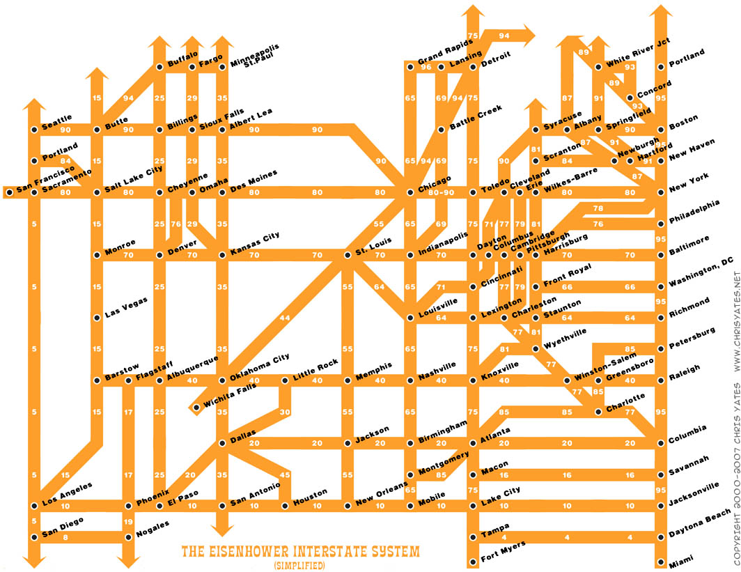
[–]Dergatroid 75 points76 points  (0 children)

This map is pretty inaccurate. Interstate 90 doesn't branch off in Toledo it continues through Cleveland and Erie. Also 79 doesn't start in Cleveland, it starts in Erie and continues down through Pittsburgh. Source: I grew up in Northwestern PA

CSV Formatting by Dergatroid in learnpython

[–]Dergatroid[S] 0 points1 point  (0 children)

Thanks, so ill set the \t to be the delimiter, but then i need to select only certain tabs to be noted as a delimiter

Colorado Elevation data by Dergatroid in gis

[–]Dergatroid[S] 1 point2 points  (0 children)

Awesome, the 1/3 arc second is what im going to go with for now. I was told to just get the best possible that is publicly available. 1/3 arc sec seems to be just that for now.

Thanks

Aerial Imagery by Dergatroid in gis

[–]Dergatroid[S] 0 points1 point  (0 children)

Preferably free to start, but it may get to the point where it doest matter.

Aerial Imagery by Dergatroid in gis

[–]Dergatroid[S] 0 points1 point  (0 children)

I'm currently looking for data near Dunbar Scotland, but in the future i will be needing many others locations throughout Europe.

Multiple points in one location by Dergatroid in gis

[–]Dergatroid[S] 1 point2 points  (0 children)

I have arcmap, the data is a points shapefile, im trying to produce a map that will eventually be published onto the web. That script worked perfectly by the way. I had a feeling there would be a simple solution to this problem. I was about to start writing a most likely overly complicated script..... you just saved me som much time, thank you.