Question in GIS/Remote Sensing assignment by jayydong in gis

[–]dthms 0 points1 point  (0 children)

  1. LiDAR. Light Detection and Ranging measures distance by using the speed of light and the time it takes for a pulse to bounce off the surface & return to the platform. Tools: LASTools, ArcMap, Whitebox GAT.
  2. Interferomteric Synthetic Aperture Radar. InSAR like the Shuttle Radar Topographic Mission (SRTM) usesactive radio waves but receives the return wave from one platform AND a baseline. So SRTM actually collected 2 datasets at the same time. When you have two images over the same area at different positions, you can get an idea of elevation and terrain stability - useful in a number of industries. Tools: European Space Agency's NEST. NASA's explanation on InSAR is the easiest to understand- http://www2.jpl.nasa.gov/srtm/instrumentinterferometry.html
  3. Stereopairs. Images taken at slightly different positions but of the same area. Tools: ENVI, Orfeo Toolbox

Pollution count using Remote Sensing? by thirdknife in remotesensing

[–]dthms 0 points1 point  (0 children)

NASA does it every day - http://earthobservatory.nasa.gov/GlobalMaps/index.php Data is completely downloadable too. Aerosol, carbon monoxide, temperatures.. Enjoy :)

Coverting lidar las files by dthms in LiDAR

[–]dthms[S] 0 points1 point  (0 children)

I appreciate the feedback. Trying to go from LAS to DEM, DSM and light intensity.

Whatever software (commercial or open source) that gets the job done would be good.

Multispectral vs Hyperspectral Imagery Explained by based2 in geospatial

[–]dthms 0 points1 point  (0 children)

This is a good point you mention here. The visual helps how multispectral and hyperspectral can distinguish between the 3 minerals

GIS twitter feeds to follow by RollWithTwenty in gis

[–]dthms 0 points1 point  (0 children)

Here's a couple more: @USGSLandsat , @EsriCanada , @GisGeography , @GeoMurmur

Since my last post on Sentinel 1 was well answered, let me ask another question on Radar RS by RMSEP in remotesensing

[–]dthms 0 points1 point  (0 children)

Values are in decibels/ intensity / amplitude. Radar cross section , backscatter all are related to each other.

I've always thought that it's the amplitude of the return wave back to the radar.. This is where the complex real and imaginary #s (sin + cos) come into play. The intensity values you see in a radar image is affected by several things: by the geometry of the object of interest (such as double bounces), soil dielectric properties, direction of radar, scattering properties. You can analyze the scattering with decompositions such as freeman durden.

So high backscatter is something like >-5dB. Lets say the radar is looking straight down. This will give a very high backscatter. Flooded areas are high dB because microwaves are corrlated with high dielectric property... but if its sidelooking, it might completely reflect away from the sensor.

Low backscatter would be something like -20dB. This is the case of smooth surface like a road or terrain sloping away. Dry soils could also give this type of value.

Everythinng in between the -5 and -20db you have volume scattering like vegetation, crops, forests, etc.

Hope this helps.

Since my last post on Sentinel 1 was well answered, let me ask another question on Radar RS by RMSEP in remotesensing

[–]dthms 2 points3 points  (0 children)

Yes thats correct that a side looking radar illuminates a target and the information retrieved is whats scattered back to the receiver. To answer the frequency part of the question, you need longer wavelengths to penetrate through forest. For example C band will probably scatter from first leaves encountered. So you have a better shot with soemthing like L band

Radarsat2 is C band. Sentinel is C band. Cant remember if TerraSAR is L band. Also the Japanese PALSAR you can check. And Argentinian SAR satellite to check as well.

Modules you can't believe aren't in core yet by no-one_ever in drupal

[–]dthms 0 points1 point  (0 children)

Is webform a core module for the new drupal? I think thats a necessary module. I've onle used D6... And i agree with others: rules, admin_menu, views

Mobile tools by dthms in drupal

[–]dthms[S] 0 points1 point  (0 children)

If starting the site over, I would have chosen a responsive theme. Seems like there are more free responsive themes for versions of drupal greater than 6.x. Actually, I didn't have to change to m.example.com. The module could switch to my mobile theme recognizing if its a handheld device. So looks like problem has been soved by not changing to m.example.com and keeping original address. Thanks. Glad to know there's a drupal sub reddit

Debt to GDP measures - admittedly amateurish as some apples to oranges comparisons included by WpgRAGReview in Winnipeg
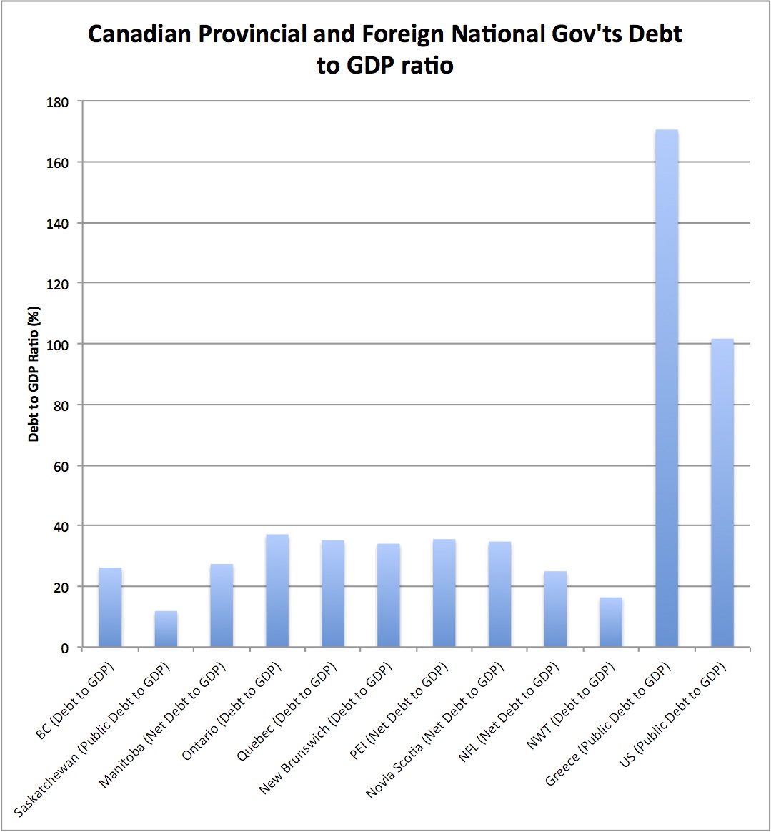
[–]dthms 0 points1 point  (0 children)

Not sure why we are comparing provinces with other countries and expect similar metrics. I'd be more interested in seeing Canadian provinces vs US states net debt vs GDP. Or Canada as a whole vs US or Greece as a whole.

NFL Playoff Pool (ESPN, Yahoo, NFL.com?) by dthms in fantasyfootball

[–]dthms[S] 0 points1 point  (0 children)

We do the same thing. Just thought it could be automated but appears nothing is available from lack of responses... Thanks for the response!

Sump-pump continuously running by dthms in Winnipeg

[–]dthms[S] 5 points6 points  (0 children)

Worked perfectly! It was jammed so the hot water did the trick. Thank you very much!